Real Roads Don’t Have Four Wheels: Exploring MOTOR in FiftyOne
Author

Hacker-in-Residence
Harpreet is Hacker-in-Residence at Voxel51, where he turns cutting-edge AI ideas into open-source prototypes and demos that push the boundaries of deep learning. From building tools that inspire to creating content that educates, Harpreet helps the AI community level up—one wild idea at a time.
See all articles by Harpreet Sahota
In this article
Key TakeawaysWhat is the MOTOR dataset?Why FiftyOne fits a multimodal dataset like MOTORLoading the datasetSeeing it: four views, one timelineWhat’s actually in the schemaThe label distributions, for realCross-tabulating labels: where the built-in Dashboard needs helpWhy the benchmark numbers matterWhy this dataset mattersGet startedFrequently Asked Questions
In this article
Key TakeawaysWhat is the MOTOR dataset?Why FiftyOne fits a multimodal dataset like MOTORLoading the datasetSeeing it: four views, one timelineWhat’s actually in the schemaThe label distributions, for realCross-tabulating labels: where the built-in Dashboard needs helpWhy the benchmark numbers matterWhy this dataset mattersGet startedFrequently Asked Questions
Try Voxel51 for yourself
FiftyOne App showing MOTOR two-wheeler rider clips with a Dashboard panel of head pose, divider, and lane-count distributions
Every driving dataset you’ve probably worked with was built around a car. nuScenes, Waymo, Cityscapes, IDD-X — four wheels, a stable chassis, a windshield-height sensor rig. That’s not what most of the world’s roads look like.
In India, Indonesia, and much of the Global South, motorcycles and scooters are the dominant mode of transport, and two-wheelers account for a disproportionate share of road fatalities relative to their numbers. Riders lean hard into turns, weave between cars, brake on a dime, and share lanes with pedestrians, pushcarts, and parked trucks — none of which a four-wheeler dataset was ever designed to capture.
MOTOR (MOtorized TwO-wheeler Rider), from Varun Paturkar, Shankar Gangisetty, and C.V. Jawahar at IIIT Hyderabad’s CVIT lab, was built to close that gap. The full release covers 1,629 annotated maneuver sequences (25+ hours) from 16 riders, captured over four weeks of real Indian traffic. A 324-clip subset of it has been imported into FiftyOne’s grouped-dataset format and published on Hugging Face as Voxel51/motor_two_wheel_rider. That’s what we’ll dig into here: four synchronized camera views per clip, GPS routes, gyroscope telemetry, and rider gaze heatmaps, all queryable in a handful of lines of Python.
Key Takeaways
- Voxel51/motor_two_wheel_rider contains 324 grouped clips × 4 camera slices (front, helmet, rear, eye_tracker) = 1,296 video samples, drawn from 14 of the original rides in the source corpus, size-budgeted to roughly 10 GB.
- Every clip contains eight emporalDetectionsT fields (event, legality, head_pose, road_type, road_marking, divider, traffic_density, n_lanes), a sample-level GPS route on the front slice, and — in 308 of 324 clips (95%) — frame-level gaze heatmaps from eye_tracker.
- FiftyOne’s Map panel only renders a GeoLocation field (singular), not GeoLocations — a real API gotcha the import pipeline has to work around, and one worth knowing before you build your own geo-enabled dataset.
- In this build, weaving through traffic, distracted driving, and violation clips are annotated 100% illegal; going straight, lane change, left turn, and stop are 100% legal — a clean structural split that says a lot about how “unspecified” maneuvers like U-turns get handled.
- In the full MOTOR benchmark, fusing RGB + gaze + telemetry on a Video Swin Transformer backbone reaches 52.9% accuracy on 11-way rider-behavior classification and 69.0% on 3-way legality classification — the best of four backbones tested and meaningfully better than RGB alone in both tasks.
- This is a size-budgeted subset of the 1,629-sequence corpus, round-robin sampled across event types for balance — great for exploring the schema and multi-view structure, not a substitute for the full corpus if you’re trying to reproduce the paper’s benchmark.
What is the MOTOR dataset?

MOTOR is a research dataset from CVIT, IIIT Hyderabad (paper, ICRA 2026). The full corpus comprises 1,629 annotated maneuver sequences (25+ hours of video) collected from 16 riders (13 male, 3 female, with 2–20 years of riding experience) over 4 weeks of naturalistic riding in India. Each ride was captured with three GoPro Hero 10 cameras (front, rear, helmet — all 1920×1080 at 30 FPS with stabilization) plus wearable eye-tracking glasses (Project Aria or Pupil Labs), synchronized GPS at 10 Hz, and gyroscope/accelerometer data at 200 Hz. The full corpus also includes on-road audio, which is not included in the FiftyOne build below.
Annotations cover four categories: traffic scene context (road type, lane count, markings, divider, density), rider state (gaze direction, GPS, speed), 12 riding maneuvers split into six conventional (going straight, left/right turn, lane change, u-turn, stop) and six unconventional behaviors (overtake, weaving through traffic, obstruction avoidance, distracted driving, traffic violation, near collision), and a legality label (Legal, Illegal, Unspecified) grounded in the Indian Motor Vehicle Act (2017).
The Hugging Face repository Voxel51/motor_two_wheel_rider is a curated, size-budgeted subset of that corpus — 324 clips (~9.7 GB), selected in a round-robin fashion across event types so no single maneuver dominates — imported into FiftyOne’s grouped-dataset format for easy multi-view exploration. It’s the FiftyOne build we’re exploring in this post, and it’s a different (smaller) thing than the full 1,629-sequence release at varunpaturkar/MOTOR.
Why FiftyOne fits a multimodal dataset like MOTOR
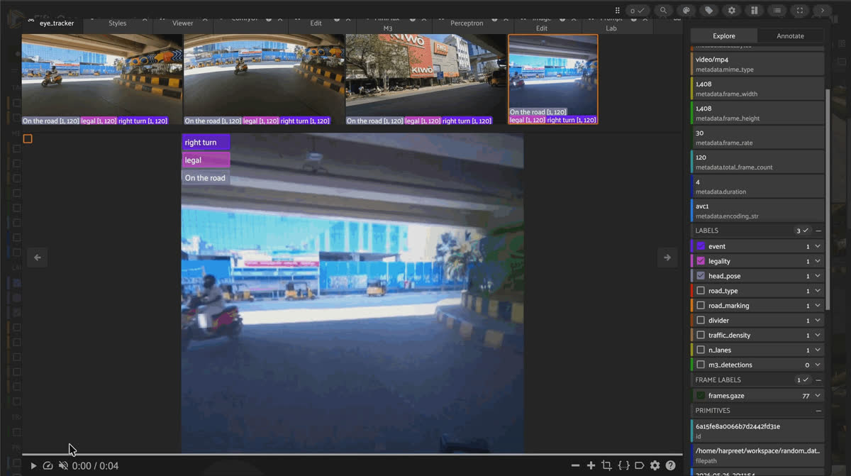
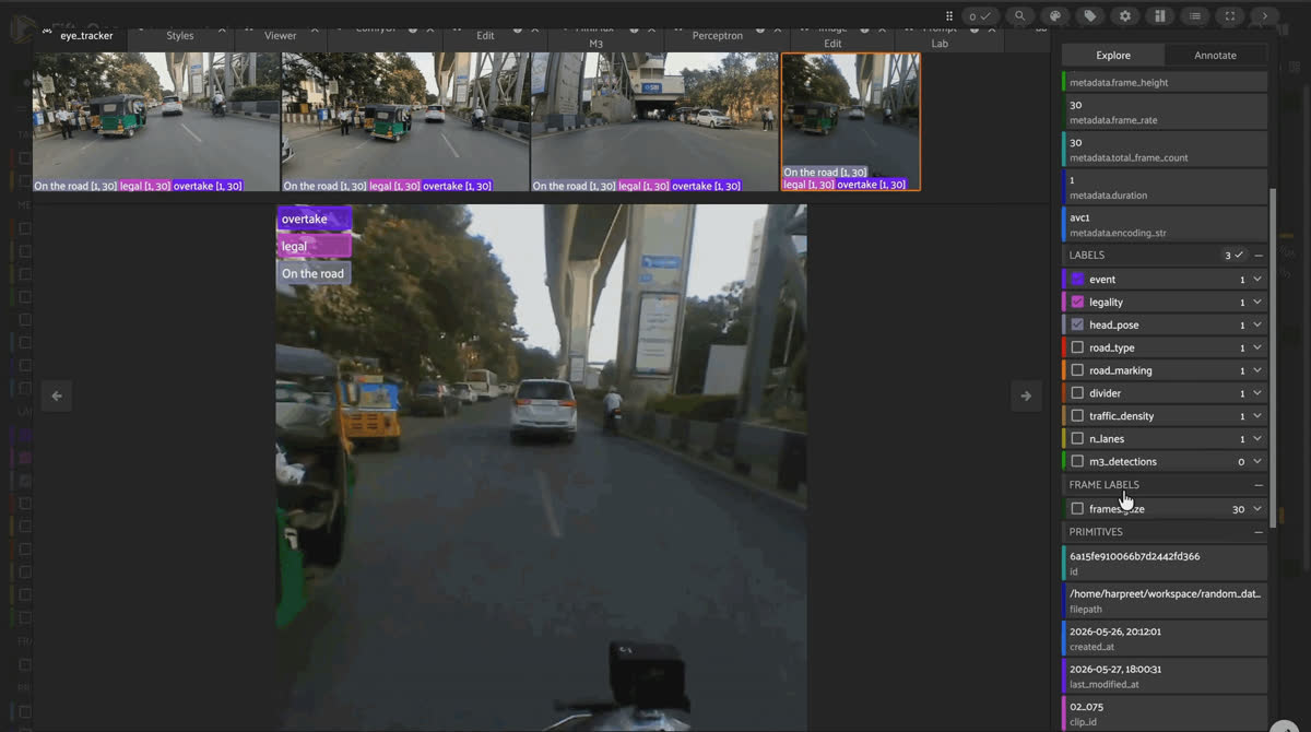
FiftyOne grouped sample of a MOTOR scooter clip under a flyover, labeled right turn, legal, and on the road
A dataset like MOTOR is awkward to explore with ordinary tooling for three reasons:
- It’s grouped and multi-view. Each clip is really four synchronized videos (front, helmet, rear, eye-tracker). A plain file browser can’t show you all four keyed to the same frame.
- It’s multimodal. Beyond pixels, you have GPS routes, per-frame telemetry, and 224×224 gaze heatmaps.
- Its labels are temporal. Behaviors like “lane change” or “weaving through traffic” span a range of frames, not a single bounding box.
FiftyOne handles all three natively. Grouped datasets (fo.Group) keep the four camera slices linked to a single clip and let you switch between them in the App using a single slice selector. TemporalDetections render frame-spanning event labels without a custom viewer. And GPS data plugs directly into the Map panel — with one real caveat.
Good to know. Why does the import script insist on fo.GeoLocation, not fo.GeoLocations? FiftyOne’s Map panel currently only looks for a GeoLocation field (singular) on your samples — it doesn’t render GeoLocations (plural), even though “a route made of many points” sounds like it should be the plural type. This is a known, open constraint (see voxel51/fiftyone#5824, confirmed by a FiftyOne core maintainer), and it’s why MOTOR’s import pipeline stores each clip’s route as a single GeoLocation with a point (the Map panel anchor) and a line (the longest unbroken GPS segment) rather than the more semantically obvious GeoLocations. If you’re building your own geo-enabled dataset, this is the kind of thing that costs an afternoon if you don’t already know it.
Loading the dataset
import fiftyone as fo
from fiftyone.utils.huggingface import load_from_hub

dataset = load_from_hub("Voxel51/motor_two_wheel_rider")

print(dataset)
print(dataset.count_values("event.detections.label"))
That single call pulls a 324-group, 1,296-sample FiftyOne dataset with four slices already wired up:
| Slice | Camera | What’s inside |
|---|---|---|
| front | Front-mounted | GPS route + frame-level telemetry (default view) |
| helmet | Helmet-mounted | First-person rider view |
| rear | Rear-mounted | What’s behind the rider |
| eye_tracker | Eye-tracker | Rider POV + 224×224 gaze heatmaps (308/324 clips) |
Seeing it: four views, one timeline
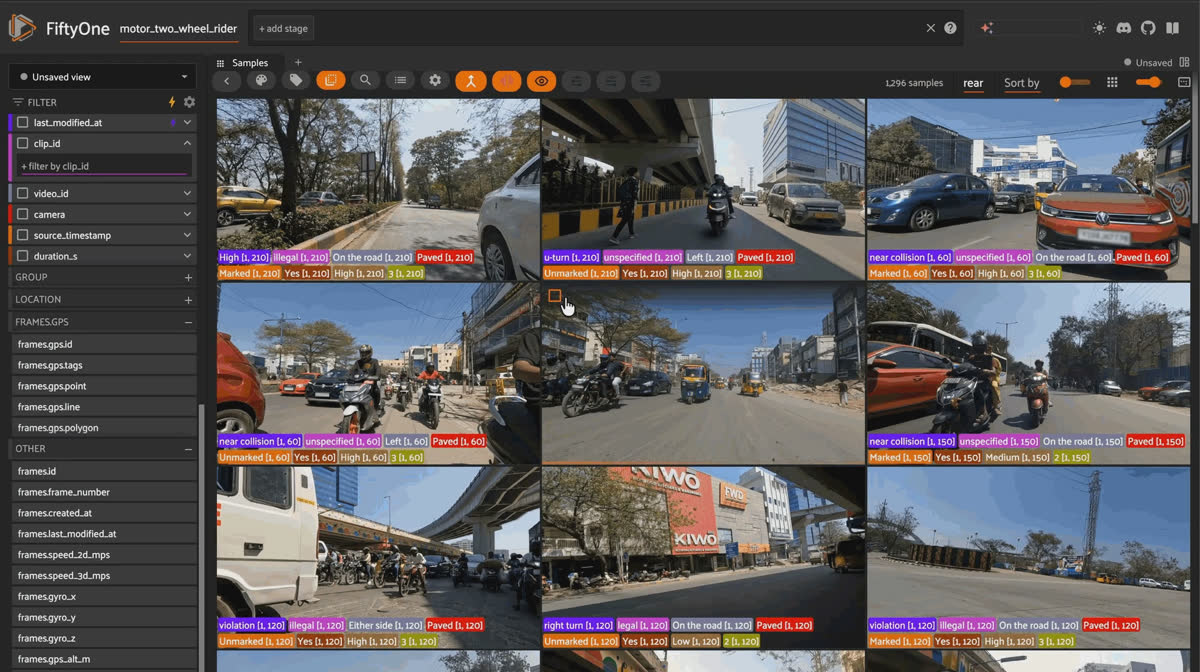
MOTOR clip playing back as four synchronized FiftyOne views: front, helmet, rear, and eye-tracker advancing together
Because the data is grouped, the most useful way to view a clip is synchronized four-pane playback — front, helmet, rear, and eye-tracker all advancing together. FiftyOne renders this natively once you launch the App on a grouped dataset:
import fiftyone as fo
from fiftyone.utils.huggingface import load_from_hub

dataset = load_from_hub("Voxel51/motor_two_wheel_rider")

session = fo.launch_app(dataset)
MOTOR clip rendered as four synchronized camera views: front, helmet, rear, and eye-tracker
Figure 1 — A real clip from the Voxel51/motor_two_wheel_rider FiftyOne build, shown as its four grouped slices. The front and helmet views capture near-identical road context from two mounting points; the rear view monitors the blind spot; the eye-tracker view provides the rider’s own gaze data.
What’s actually in the schema
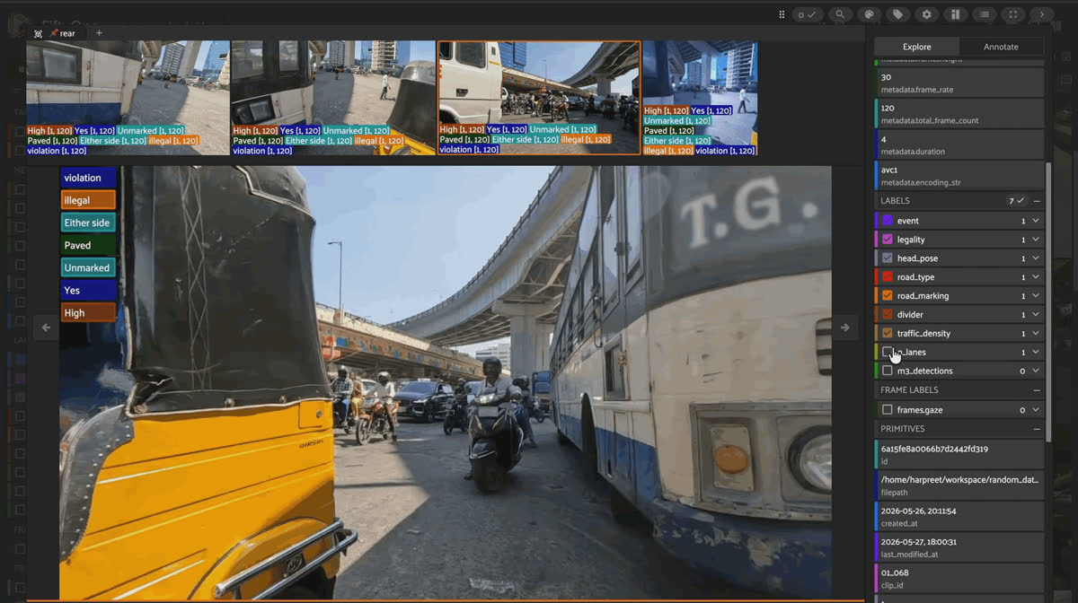
FiftyOne sample view of a MOTOR clip behind a bus in dense traffic, showing clip-level metadata and temporal detection fields
Each sample — regardless of camera slice — carries the same clip-level metadata and the same eight TemporalDetections fields (they’re duplicated across all four slices during import, since they describe the clip, not the camera):
| Field | Type | Description |
|---|---|---|
| clip_id | String | Unique clip ID (e.g. "01_012") |
| video_id | Integer | Source ride ID |
| camera | String | front / helmet / rear / eye_tracker |
| source_timestamp | String | Position in the full ride (MM:SS-MM:SS) |
| duration_s | Float | Clip duration in seconds |
| location | GeoLocation | GPS route (front slice only) |
| event | TemporalDetections | Primary riding maneuver |
| legality | TemporalDetections | Legal / illegal / unspecified |
| head_pose | TemporalDetections | Rider head direction |
| road_type | TemporalDetections | Paved / unpaved |
| road_marking | TemporalDetections | Marked / unmarked lanes |
| divider | TemporalDetections | Lane divider yes/no |
| traffic_density | TemporalDetections | Low / medium / high |
| n_lanes | TemporalDetections | Number of lanes (1–5) |
On the front slice, frames also carry telemetry: gps (a per-frame GeoLocation point), speed_2d_mps, speed_3d_mps, gyro_x/gyro_y/gyro_z, gps_alt_m, and telemetry_timestamp_s. On eye_tracker, frames carry gaze, a Gaussian heatmap field.
Keep it honest. A few things worth knowing before you build on top of this subset: - All 324 clips have a GPS route on location, but gaze heatmaps were only available for 308 of 324 clips (95%) — extraction from the red-marker overlay on the eye-tracker video doesn’t succeed in every clip. - The near-collision class has only 12 examples here (vs. ~28–29 for most other event types), because it’s genuinely rare in the source corpus — the paper itself excludes it from its 11-way behavior classification benchmark for the same reason. - One clip (01_012) has "High" recorded as its event label instead of a maneuver name — a stray annotation-import artifact affecting 1 of 324 clips, not a systemic issue. - Clip durations run from 1 to 30 seconds, with 85% of clips under 6 seconds — shorter than the “typically 1–20 seconds” description on the dataset card, which describes the full corpus rather than this specific subset. - On-road audio, part of the original MOTOR capture rig, isn’t included in this FiftyOne build.
The label distributions, for real
Querying the annotations directly (dataset.count_values(field)) on the 324 front-slice samples gives you the actual shape of this subset:
Legality — 165 legal (51%), 91 illegal (28%), 68 unspecified (21%)
Traffic density — 139 low (43%), 66 medium (20%), 119 high (37%)
Road type — 312 paved (96%), 12 unpaved (4%)
Road markings — 224 marked (69%), 100 unmarked (31%)
Lane divider — 252 yes (78%), 72 no (22%)
Number of lanes — 80 one-lane, 94 two-lane, 120 three-lane, 28 four-lane, 2 five-lane
Head pose — 214 on the road (66%), 58 left (18%), 32 right (10%), 20 either side (6%)
from fiftyone import ViewField as F

illegal = dataset.match(F("legality.detections.label") == "illegal")
print(len(illegal), "of", len(dataset), "clips are annotated illegal")
Cross-tabulating labels: where the built-in Dashboard needs help
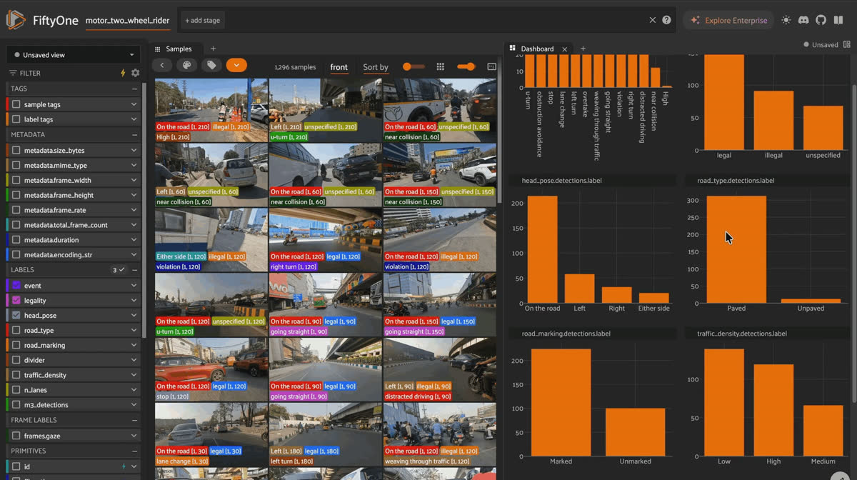
FiftyOne Dashboard cross-tabulating MOTOR event, legality, head pose, road type, and traffic density label distributions
FiftyOne’s built-in Dashboard panel handles single-field distributions out of the box, but a few of the more interesting questions about MOTOR require zipping two parallel TemporalDetections fields together — something the built-in form can’t do, but a few lines of dataset.values() can:
dataset = ctx.dataset  # inside a custom Dashboard plot

event_labels = dataset.values("event.detections.label")
legality_labels = dataset.values("legality.detections.label")
Running that cross-tab over this subset surfaces a clean three-way split: distracted driving, violation, and weaving through traffic clips are 100% illegal; going straight, lane change, left turn, and stop clips are 100% legal; and u-turn (illegal in only 1 of 29 clips) and obstruction avoidance (illegal in only 2 of 29) are overwhelmingly annotated unspecified rather than illegal — maneuvers the Indian Motor Vehicle Act doesn’t explicitly regulate.
The same technique applied to head_pose vs. event shows rider attention tracks maneuver risk in an intuitive way: distracted driving is 100% off-road by definition, but u-turn (62% off-road) and violation (50%) show riders looking away far more than lane change (7%) or overtake (4%) — maneuvers that demand active attention to execute.
And event vs. duration_s shows maneuver complexity in seconds: u-turn clips average 8.0s and stop clips 5.8s, while obstruction avoidance (1.1s) and lane change (1.25s) are essentially instantaneous — reactive swerves rather than deliberate, sustained maneuvers. near collision clips average 2.4 seconds in this subset, which lines up closely with the 2.4-second figure the MOTOR paper reports for the full 1,629-sequence corpus.
Why the benchmark numbers matter
The MOTOR paper benchmarks four video backbones — CNN-based S3D and ResNet3D, transformer-based MViTv2 and Video Swin Transformer (SwinT) — on the full 1,629-sequence corpus, with and without gaze and telemetry fusion. A few results worth knowing if you’re evaluating this data for your own research:
- Rider behavior classification (11 classes, near-collision excluded for data sparsity): SwinT with RGB+gaze+telemetry reaches 52.9% accuracy / 51.5% F1, the best of the four backbones. Removing gaze costs 1.6% accuracy; removing telemetry costs 2.6%; removing both costs 5.2% — telemetry is the stronger standalone signal, but gaze and telemetry together beat either alone.
- Legality classification (Legal / Illegal / Unspecified): SwinT with full fusion reaches 69.0% accuracy / 53.6% F1. Here the gap is bigger — removing gaze costs 4.0% accuracy, removing telemetry costs 6.3%, and removing both costs 10.6%, meaning non-visual cues (speed, lean angle, attention) matter even more for judging legality than for recognizing the maneuver itself.
- The most common confusions (per the paper’s confusion-matrix analysis): obstruction avoidance gets mistaken for lane change or overtake (all three involve lateral deviation), and traffic violations get missed when the scene-level cues that define them — a signal, a lane marking — aren’t clearly visible in dense, unstructured traffic.
None of these numbers come from labels in the FiftyOne build itself — they’re the paper’s benchmark on the full corpus — but they’re the reason the modalities in this dataset (gaze, telemetry, not just RGB) matter for anyone building on top of it.
Why this dataset matters
- Safety research. Two-wheelers dominate urban mobility across much of the world but are wildly underrepresented in behavioral driving datasets. MOTOR helps close that gap.
- ADAS for motorcycles. Lane-change, obstruction-avoidance, and violation detection models can be trained and benchmarked on realistic, unstructured traffic — not the sanitized, lane-disciplined driving that four-wheeler datasets assume.
- Multimodal fusion. Video + gaze + telemetry, with a benchmark showing each modality contributes measurably, is a clean testbed for fusion architectures.
- Attention modeling. Gaze heatmaps let you study where riders look during risky maneuvers — a real supervisory signal for learned visual attention.
Get started
pip install -U fiftyone
import fiftyone as fo
from fiftyone.utils.huggingface import load_from_hub

dataset = load_from_hub("Voxel51/motor_two_wheel_rider")
session = fo.launch_app(dataset)  # explore the four-slice grouped App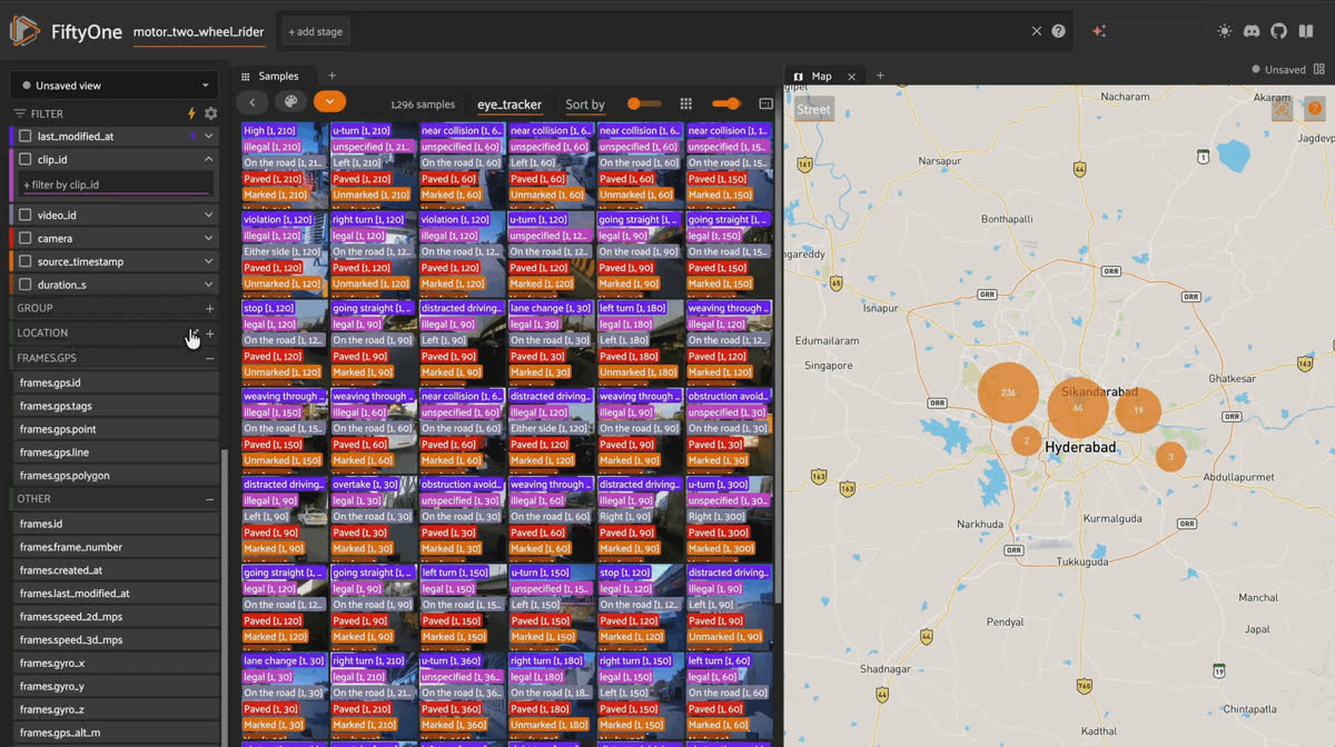
FiftyOne grid of MOTOR eye-tracker slice clips with event, legality, and road-context labels across Indian traffic scenes
To render GPS routes in the Map panel, sign up for a free Mapbox account, grab an access token, and export it before launching:
export MAPBOX_TOKEN=your_mapbox_token_here- Hugging Face (FiftyOne build): Voxel51/motor_two_wheel_rider
- Hugging Face (full corpus): varunpaturkar/MOTOR
- Paper: MOTOR: A Multimodal Dataset for Two-Wheeler Rider Behavior Understanding (ICRA 2026)
- Project page: varuniiith.github.io/MOTOR-Dataset
- License: Research use only, CC BY-NC 4.0 (as specified by the original authors)
Frequently Asked Questions
What’s the difference between Voxel51/motor_two_wheel_rider and varunpaturkar/MOTOR?
varunpaturkar/MOTOR is the full research release: 1,629 annotated sequences, 25+ hours, from the paper’s authors. Voxel51/motor_two_wheel_rider is a 324-clip, ~9.7 GB subset of that corpus, re-packaged into FiftyOne’s grouped-dataset format with four synchronized camera slices per clip. If you need the complete corpus for training or reproducing the paper’s benchmarks, go to varunpaturkar/MOTOR; if you want to quickly explore the schema, multi-view structure, and label taxonomy, Voxel51/motor_two_wheel_rider is built for that.
How many samples are actually in the FiftyOne dataset?
324 groups, each with 4 slices (front, helmet, rear, eye_tracker), for a total of 1,296 video samples. len(dataset) and dataset.count_values("camera") will both report against the default front slice (324), since FiftyOne counts groups, not raw samples, by default on grouped datasets.
What are the event classes?
Twelve: six conventional (straight, left turn, right turn, lane change, U-turn, stop) and six unconventional (overtake, weaving through traffic, obstruction avoidance, distracted driving, violation, near-collision). The paper’s own behaviour-classification benchmark drops near-collision to 11 classes because it’s too sparse to train on reliably.
Is legality ground truth or a model prediction?
Ground truth. Two professional annotators, trained on maneuver and traffic-violation definitions from the Indian Motor Vehicle Act (2017), labeled the sequences under expert supervision, with the first 50 sequences cross-checked by both annotators before the rest were split up.
Does the FiftyOne build include the on-road audio from the original capture rig?
No. The paper’s data-collection setup captures ambient audio (horns, engine noise, rider speech) alongside video and telemetry, but the Voxel51/motor_two_wheel_rider FiftyOne build doesn’t include an audio field.
Why is location a GeoLocation and not GeoLocations?
Because FiftyOne’s Map panel only detects a GeoLocation field, not GeoLocations — a real, currently-open constraint in FiftyOne itself (see voxel51/fiftyone#5824). The import pipeline stores each route’s centroid as a point and its longest unbroken GPS segment as a line, both inside a single GeoLocation.
Hacker-in-Residence
Harpreet is Hacker-in-Residence at Voxel51, where he turns cutting-edge AI ideas into open-source prototypes and demos that push the boundaries of deep learning. From building tools that inspire to creating content that educates, Harpreet helps the AI community level up—one wild idea at a time.
See all articles by Harpreet Sahota
Try Voxel51 for yourself
Loading related posts...
© 2026 Voxel51 All Rights Reserved


